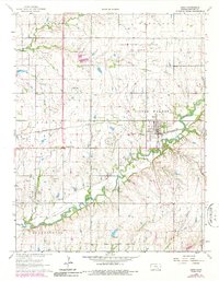
1963 Map of Leon
USGS Topo · Published 1986About this map
The Little Walnut River carves a winding path across this portion of Butler County, anchoring a landscape defined by the mid-century intersection of agriculture and the petroleum industry. The town of Leon serves as the primary hub, situated along the St Louis-San Francisco railroad line which facilitated the transport of local resources. This 1963 survey, updated with 1978 revisions, reveals an extensive network of energy extraction including the El Dorado Oil Field, Garden Reynolds Shaffer Oil Field, and Leon Oil Field. For genealogists and local historians, the sheet is particularly valuable for its documentation of family-named landmarks and rural burial sites such as Butts-Wakefield Cem, Garrison Cem, and Bogle Cem. Beyond the oil derricks, the map tracks land use through numerous Gravel Pits and the small crossroads at Pickrell Corner.
Find a feature on this map
26 named features on this map. Tap any name to fly to it.
Don’t see what you’re looking for? This feature index may not catch every label — zoom into the map to look around manually.
Map Details
Editions of this 1963 Leon Map
3 editions found
Other maps of this area

1888 · Eldorado
USGS Topo · 1:125,000

1955 · Wichita
USGS Topo · 1:250,000

1958 · Wichita
USGS Topo · 1:250,000

1961 · Augusta
USGS Topo · 1:24,000

1961 · Pontiac
USGS Topo · 1:24,000

1961 · El Dorado
USGS Topo · 1:24,000

1961 · Gordon
USGS Topo · 1:24,000
1961 · El Dorado SW
USGS Topo · 1:24,000

1963 · Leon
USGS Topo · 1:24,000

1964 · Augusta SE
USGS Topo · 1:24,000