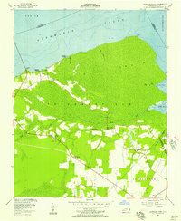
1954 Map of Leonards Point
USGS Topo · Published 1957About this map
Big Skinnerville Swamp dominates this coastal landscape in Washington County, showing a complex network of wetlands and ditches that defined the local economy and movement during the mid-1950s. The northern edge of the map follows the irregular shoreline of Albemarle Sound, where historical points of access like Newberry Landing and Shadberry Landing served the residents of small settlements such as Pea Ridge. Inland, the map reveals a community centered around rural social anchors, including Piney Grove Ch, Scuppernong Ch, and Mt Pleasant Ch.
Find a feature on this map
32 named features on this map. Tap any name to fly to it.
Don’t see what you’re looking for? This feature index may not catch every label — zoom into the map to look around manually.
Map Details
Editions of this 1954 Leonards Point Map
2 editions found
Other maps of this area

1904 · Edenton
USGS Topo · 1:62,500

1906 · Hertford
USGS Topo · 1:62,500

1940 · Hertford
USGS Topo · 1:62,500

1942 · Edenton
USGS Topo · 1:62,500

1943 · Columbia
USGS Topo · 1:125,000

1943 · Plymouth
USGS Topo · 1:125,000

1943 · Edenton
USGS Topo · 1:62,500

1953 · Norfolk
USGS Topo · 1:250,000

1953 · Columbia West
USGS Topo · 1:24,000

1953 · Rocky Mount
USGS Topo · 1:250,000