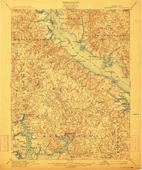
1901 Map of Leonardtown
USGS Topo · Published 1913About this map
Leonardtown serves as a central hub in this Southern Maryland landscape, where the tidal waters of the Patuxent River and St. Clement Bay define the region's geography and economy. At the turn of the century, this area relied heavily on a network of steamboat landings and wharves for transportation and commerce. Prominent maritime points such as Sotterley Wharf, Williams Wharf, and Jones Wharf line the riverbanks, marking where agricultural goods and supplies moved through the Tidewater. The map illustrates a densely settled rural interior with clusters at Mechanicsville, Hollywood, and Morganza. To the west, Chaptico Run and Mc. Intosh Run feed the bay system, while to the east, the boundary between St. Marys Co. and Calvert Co. follows the deep water of the Patuxent, connecting smaller outposts like Broome Island and Wallville to the mainland trade.
Find a feature on this map
97 named features on this map. Tap any name to fly to it.
Don’t see what you’re looking for? This feature index may not catch every label — zoom into the map to look around manually.
Map Details
Editions of this 1901 Leonardtown Map
3 editions found
Other maps of this area

1892 · Leonardtown
USGS Topo · 1:62,500

1892 · Drum Point
USGS Topo · 1:62,500

1892 · Prince Frederick
USGS Topo · 1:62,500

1892 · Brandywine
USGS Topo · 1:62,500

1892 · Piney Point
USGS Topo · 1:62,500

1892 · Montross
USGS Topo · 1:62,500

1893 · Sharps Island
USGS Topo · 1:62,500

1894 · Wicomico
USGS Topo · 1:62,500

1894 · Piney Point
USGS Topo · 1:62,500

1894 · Point Lookout
USGS Topo · 1:62,500
Featured Places
- Lexington Park, MD
- California, Lexington Park
- Wildewood, Lexington Park
- Golden Beach, MD
- Leonardtown, MD