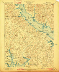
1901 Map of Leonardtown
USGS Topo · Published 1901About this map
Leonardtown serves as the focal point of this coastal survey, where the tidewater geography of the Patuxent River and its numerous tributaries dictated the economy and transit of Southern Maryland. The landscape is defined by an intricate network of landings and wharves, such as Sotterly Wharf, Forest Wharf, and Abells Wharf, which provided essential maritime access for the surrounding tobacco-growing districts. The transition from the Hillville District to the Mechanicsville District reveals a pattern of dispersed rural settlements and small crossroads communities like Hollywood, Oakville, and Loveville. Significant waterways including St. Leonard Creek and Battle Creek carve deep into the shoreline, creating a terrain where water travel remained as vital as the emerging inland roads.
Find a feature on this map
106 named features on this map. Tap any name to fly to it.
Don’t see what you’re looking for? This feature index may not catch every label — zoom into the map to look around manually.
Map Details
Editions of this 1901 Leonardtown Map
3 editions found
Other maps of this area

1892 · Leonardtown
USGS Topo · 1:62,500

1892 · Drum Point
USGS Topo · 1:62,500

1892 · Prince Frederick
USGS Topo · 1:62,500

1892 · Brandywine
USGS Topo · 1:62,500

1892 · Piney Point
USGS Topo · 1:62,500

1892 · Montross
USGS Topo · 1:62,500

1893 · Sharps Island
USGS Topo · 1:62,500

1894 · Wicomico
USGS Topo · 1:62,500

1894 · Piney Point
USGS Topo · 1:62,500

1894 · Point Lookout
USGS Topo · 1:62,500
Featured Places
- Lexington Park, MD
- California, Lexington Park
- Wildewood, Lexington Park
- Golden Beach, MD
- Leonardtown, MD