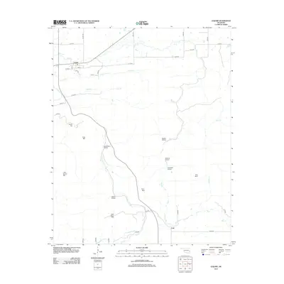
2012 Map of Lequire
USGS Topo · Published 2012About this map
Lequire serves as the primary settlement in this corner of Haskell County, where the grid of residential streets like Main St and Oak St meets the winding Liquire Hwy. The landscape is defined by its dramatic vertical relief, characterized by a series of named hollows and peaks that dictate the local drainage and transportation patterns. Waterways such as Turkey Cr and Andrew Cr cut through the terrain near the townsite, while more isolated features like Little Round Mtn and Long Mtn rise above the surrounding valleys. To the south, the smaller community of Lodi is situated near the banks of Rock Cr, illustrating the typical placement of Oklahoma hill country settlements along accessible creek beds. This map provides a detailed look at the rural road network, including numerous numbered routes like E1310 Rd and N4470 Rd, which connect remote homesteads to the area's natural landmarks like Ryan Peak and Red Bluff.
Find a feature on this map
43 named features on this map. Tap any name to fly to it.
Don’t see what you’re looking for? This feature index may not catch every label — zoom into the map to look around manually.
Map Details
Editions of this 2012 Lequire Map
This is the sole edition of this map. No revisions or reprints were ever made.
Other maps of this area

1900 · Sansbois
USGS Topo · 1:125,000

1900 · Sallisaw
USGS Topo · 1:125,000

1900 · Winding Stair
USGS Topo · 1:125,000

1901 · Tuskahoma
USGS Topo · 1:125,000

1908 · Tuskahoma
USGS Topo · 1:125,000

1909 · Tuskahoma
USGS Topo · 1:125,000

1909 · Winding Stair
USGS Topo · 1:125,000

1909 · Sans Bois
USGS Topo · 1:125,000

1911 · Sallisaw
USGS Topo · 1:125,000

1911 · Sansbois
USGS Topo · 1:125,000