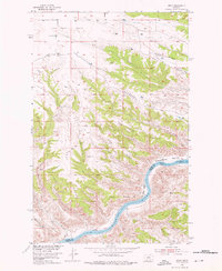
1954 Map of Leroy
USGS Topo · Published 1976About this map
Missouri River currents dominate the southern portion of this mid-century survey, cutting through the high country of the Blaine and Fergus County line. The landscape is defined by its deep erosion, with prominent features like Red Rock Ridge and Barnard Ridge rising above the river bottoms. In the north, the terrain levels out into the Lone Tree Bench, where the rural community of Leroy and the Lone Tree Bench Sch served the local ranching and farming families of the era.
Find a feature on this map
19 named features on this map. Tap any name to fly to it.
Don’t see what you’re looking for? This feature index may not catch every label — zoom into the map to look around manually.
Map Details
Editions of this 1954 Leroy Map
2 editions found
Other maps of this area

1954 · Taffy Ridge
USGS Topo · 1:24,000

1954 · Bird Rapids
USGS Topo · 1:24,000

1954 · Leroy
USGS Topo · 1:24,000

1954 · Gallatin Rapids
USGS Topo · 1:24,000

1954 · Lewistown
USGS Topo · 1:250,000

1959 · Lewistown
USGS Topo · 1:250,000

1964 · Ragland Bench
USGS Topo · 1:24,000
1985 · Nolan Reservoir
USGS Topo · 1:24,000

1985 · Woodhawk Hill
USGS Topo · 1:24,000
1985 · Sandpiper Reservoir
USGS Topo · 1:24,000