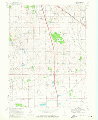
1969 Map of Leroy
USGS Topo · Published 1971About this map
The unincorporated settlement of Leroy sits at the junction of the Penn Central railroad and Niles Ditch in this southern Lake County study. The landscape is defined by its transition from natural drainage to a heavily engineered water system, with Stony Run and its branches giving way to a network of drainage canals like the Mississippi Ditch and Singleton Ditch. This infrastructure highlights the agricultural shift of the region, where once-isolated hamlets were connected by a strict grid of rural routes including 153d Avenue and 189th Avenue.
Find a feature on this map
33 named features on this map. Tap any name to fly to it.
Don’t see what you’re looking for? This feature index may not catch every label — zoom into the map to look around manually.
Map Details
Editions of this 1969 Leroy Map
2 editions found
Other maps of this area

1953 · Leroy
USGS Topo · 1:24,000

1953 · St. John
USGS Topo · 1:24,000

1953 · Palmer
USGS Topo · 1:24,000

1953 · Crown Point
USGS Topo · 1:24,000

1953 · Hebron
USGS Topo · 1:24,000

1953 · Lowell
USGS Topo · 1:24,000

1953 · Chicago
USGS Topo · 1:250,000

1957 · Chicago
USGS Topo · 1:250,000

1957 · DeMotte
USGS Topo · 1:24,000

1959 · Schneider
USGS Topo · 1:24,000