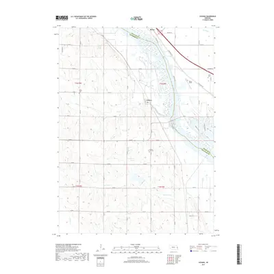
2017 Map of Leshara
USGS Topo · Published 2017About this map
Leshara and the small settlement of Mercer sit along the western banks of the Platte River in this 2017 study of eastern Nebraska. The landscape is defined by the river's wide, braided channel and the numerous tributaries that drain into it, including Otoe Creek and Upper Clear Creek. The terrain reveals a transition from the river valley to higher ground, where a grid of rural routes such as County Road 7 and County Road 8 connects isolated farmsteads and landmarks. Genealogists will find several burial sites preserved on this sheet, including Little Flower Cemetery, Valley Cemetery, and Pleasant View Cemetery. To the east of the river, Werner Airport and developments along Ginger Cove Road indicate the modern expansion of suburban outskirts into the traditionally agricultural river plain.
Find a feature on this map
48 named features on this map. Tap any name to fly to it.
Don’t see what you’re looking for? This feature index may not catch every label — zoom into the map to look around manually.
Map Details
Editions of this 2017 Leshara Map
This is the sole edition of this map. No revisions or reprints were ever made.
Other maps of this area

1893 · Fremont
USGS Topo · 1:125,000

1896 · Fremont
USGS Topo · 1:125,000

1899 · Wahoo
USGS Topo · 1:125,000

1955 · Fremont
USGS Topo · 1:250,000

1957 · Fremont
USGS Topo · 1:250,000

1958 · Fremont
USGS Topo · 1:250,000

1968 · Valley
USGS Topo · 1:24,000

1968 · Leshara
USGS Topo · 1:24,000
1968 · Fremont West
USGS Topo · 1:24,000

1968 · Fremont East
USGS Topo · 1:24,000