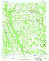
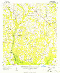
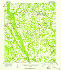
1956 Map of Leslie
USGS Topo · Published 1969About this map
Starksville and Smithville anchor this mid-century look at the agricultural and transit landscape of the Georgia coastal plain. The Central Of Georgia and Seaboard Air Line railroads intersect the terrain, defining the growth patterns of small trackside communities like Leslie and De Soto. Away from the rail lines, the landscape is heavily influenced by the drainage basins of Muckalee Creek and Muckaloochee Creek, where numerous rural institutions such as Nunn Industrial Sch and Marthanna Grove Ch serve scattered farming homesteads.
Find a feature on this map
64 named features on this map. Tap any name to fly to it.
Don’t see what you’re looking for? This feature index may not catch every label — zoom into the map to look around manually.
Map Details
Editions of this 1956 Leslie Map
2 editions found
Other maps of this area

1953 · Dothan
USGS Topo · 1:250,000

1953 · Waycross
USGS Topo · 1:250,000

1954 · Dothan
USGS Topo · 1:250,000

1955 · Dothan
USGS Topo · 1:250,000

1955 · Phenix City
USGS Topo · 1:250,000

1956 · Sylvester
USGS Topo · 1:62,500
1956 · Sasser
USGS Topo · 1:62,500

1956 · Albany
USGS Topo · 1:62,500
1956 · Leslie
USGS Topo · 1:62,500

1957 · Phenix City
USGS Topo · 1:250,000