1973 Map of Leslie SE
USGS Topo · Published 1976About this map
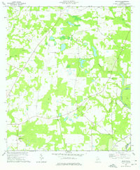
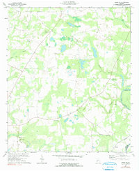
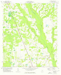
Flint River frontage defines the eastern boundary of this Georgia landscape, marking the transition between Lee and Worth counties. This 1970s survey captures a largely agricultural region characterized by scattered settlements and rural landmarks. Small communities like Tarpley and Philema are positioned along the local road network, while the western edge features the small locale of Mossy Dell near a natural Spring.
Find a feature on this map
16 named features on this map. Tap any name to fly to it.
Don’t see what you’re looking for? This feature index may not catch every label — zoom into the map to look around manually.
Map Details
Editions of this 1973 Leslie SE Map
2 editions found
Other maps of this area

1953 · Dothan
USGS Topo · 1:250,000

1953 · Waycross
USGS Topo · 1:250,000

1954 · Dothan
USGS Topo · 1:250,000

1955 · Dothan
USGS Topo · 1:250,000

1956 · Sylvester
USGS Topo · 1:62,500

1956 · Albany
USGS Topo · 1:62,500
1956 · Leslie
USGS Topo · 1:62,500

1958 · Waycross
USGS Topo · 1:250,000
1973 · Albany NE
USGS Topo · 1:24,000
1973 · Neyami
USGS Topo · 1:24,000