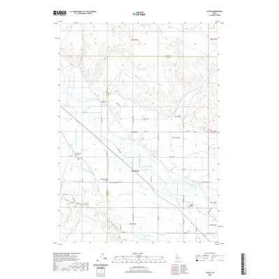
2020 Map of Letha
USGS Topo · Published 2020About this map
Letha and the surrounding irrigated plains of the Lower Payette Valley define this riverine landscape in Gem and Payette counties. The Payette River meanders across the center of the sheet, feeding an intricate network of man-made waterways like the Farmers Cooperative Canal and the Noble Canal. This irrigation system supports agricultural life on the Emmett Bench and the broader Emmett-Valley, where small settlements like Little Rock and Sand Hollow are linked by a grid of rural roads. Historical landmarks such as the Falk Cem and Falk Bridge provide anchors for genealogists and local historians. The northern portion of the map transitions into higher terrain marked by Graveyard Gulch, creating a stark contrast to the structured sloughs and ditches that crisscross the river bottomlands.
Find a feature on this map
63 named features on this map. Tap any name to fly to it.
Don’t see what you’re looking for? This feature index may not catch every label — zoom into the map to look around manually.
Map Details
Editions of this 2020 Letha Map
This is the sole edition of this map. No revisions or reprints were ever made.
Other maps of this area

1897 · Weiser
USGS Topo · 1:125,000

1898 · Nampa
USGS Topo · 1:125,000

1952 · Birding Island
USGS Topo · 1:24,000

1955 · Baker
USGS Topo · 1:250,000

1955 · Boise
USGS Topo · 1:250,000

1958 · Boise
USGS Topo · 1:250,000

1959 · Baker
USGS Topo · 1:250,000

1962 · Boise
USGS Topo · 1:250,000
1965 · New Plymouth
USGS Topo · 1:24,000
1965 · Parma SE
USGS Topo · 1:24,000