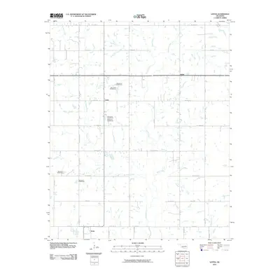
2010 Map of Letitia
USGS Topo · Published 2010About this map
Letitia and the surrounding prairie of Stephens County are defined by a network of rural section-line roads and numerous small impoundments. The landscape is drained by Beaver Creek and its tributaries, including Dry Beaver Creek and Armstrong Creek, which meander through a series of local reservoirs. These water bodies are identified by state dam records, such as Oknoname 031057 Dam and Oknoname 031032 Dam, indicating the importance of water management in this agricultural region. The tiny settlement of Bethel sits at a crossroads in the northeast, while Hulen anchors the southwest corner near Base Line Rd. A rigid grid of thoroughfares like E Gore Blvd and Beech Rd provides the primary structure for the dispersed farmsteads and rural residences that characterize the area at the start of the 21st century.
Find a feature on this map
43 named features on this map. Tap any name to fly to it.
Don’t see what you’re looking for? This feature index may not catch every label — zoom into the map to look around manually.
Map Details
Editions of this 2010 Letitia Map
This is the sole edition of this map. No revisions or reprints were ever made.
Other maps of this area

1946 · Lawton
USGS Topo · 1:62,500

1949 · Arbuckle Hill
USGS Topo · 1:24,000

1949 · Nellie
USGS Topo · 1:62,500

1955 · Lawton
USGS Topo · 1:250,000

1956 · Sterling
USGS Topo · 1:24,000

1956 · Ninemile Creek
USGS Topo · 1:24,000

1956 · Arbuckle Hill
USGS Topo · 1:24,000
1956 · Denton
USGS Topo · 1:24,000

1956 · Letitia
USGS Topo · 1:24,000

1956 · Nellie
USGS Topo · 1:24,000