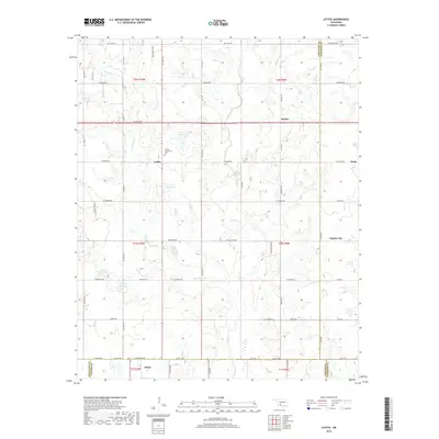
2018 Map of Letitia
USGS Topo · Published 2018About this map
The Letitia Community Cem serves as a central landmark for this rural region where the borders of Comanche, Stephens, and Cotton counties converge. This landscape is defined by the drainage basins of Dry Beaver Cr and Beaver Cr, which meander through a grid of section-line roads and cattle country. Small, historic settlements like Letitia, Bethel, and Nellie anchor the northern half of the area, while Hulen sits at the southern edge. The distribution of small water bodies, such as 031034 Reservoir, reveals the importance of water management for local ranching and agriculture in the Oklahoma plains. Toward the east, the map captures the outskirts of Empire City, reflecting the slow expansion of more established communities into the surrounding prairie.
Find a feature on this map
62 named features on this map. Tap any name to fly to it.
Don’t see what you’re looking for? This feature index may not catch every label — zoom into the map to look around manually.
Map Details
Editions of this 2018 Letitia Map
This is the sole edition of this map. No revisions or reprints were ever made.
Other maps of this area

1946 · Lawton
USGS Topo · 1:62,500

1949 · Arbuckle Hill
USGS Topo · 1:24,000

1949 · Nellie
USGS Topo · 1:62,500

1955 · Lawton
USGS Topo · 1:250,000

1956 · Sterling
USGS Topo · 1:24,000

1956 · Ninemile Creek
USGS Topo · 1:24,000

1956 · Arbuckle Hill
USGS Topo · 1:24,000
1956 · Denton
USGS Topo · 1:24,000

1956 · Letitia
USGS Topo · 1:24,000

1956 · Nellie
USGS Topo · 1:24,000