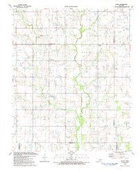
1991 Map of Letitia
USGS Topo · Published 1991About this map
Pumpkin Center and Letitia anchor the rural landscape of south-central Oklahoma at the start of the 1990s. The map illustrates a region defined by agricultural plots and significant petroleum extraction, with numerous Oil Wells and larger Oil Fields scattered across the township lines of Comanche and Stephens counties. The drainage patterns of Dry Beaver Creek and the main branch of Beaver Creek dictate the local topography, while small communities like Bethel and Hulen serve as local landmarks. Cultural sites of interest to genealogists include the local Cemetery near Letitia and Hulen Church further south. The infrastructure is rounded out by utility installations such as a Substation, Radio Tower, and Pumping Station, indicating the industrial overlay on this predominantly rural prairie landscape.
Find a feature on this map
19 named features on this map. Tap any name to fly to it.
Don’t see what you’re looking for? This feature index may not catch every label — zoom into the map to look around manually.
Map Details
Editions of this 1991 Letitia Map
This is the sole edition of this map. No revisions or reprints were ever made.
Other maps of this area

1946 · Lawton
USGS Topo · 1:62,500

1949 · Arbuckle Hill
USGS Topo · 1:24,000

1949 · Nellie
USGS Topo · 1:62,500

1955 · Lawton
USGS Topo · 1:250,000

1956 · Sterling
USGS Topo · 1:24,000

1956 · Ninemile Creek
USGS Topo · 1:24,000

1956 · Arbuckle Hill
USGS Topo · 1:24,000
1956 · Denton
USGS Topo · 1:24,000

1956 · Letitia
USGS Topo · 1:24,000

1956 · Nellie
USGS Topo · 1:24,000