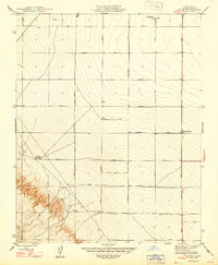
1947 Map of Levis
USGS Topo · Published 1947About this map
The agricultural grid of Fresno County is meticulously documented in this post-war revision of a 1921 survey, overseen by State of California officials including Governor Earl Warren. The landscape is dominated by a systematic network of east-west corridors, ranging from South Avenue to Clark Avenue, intersected by north-south routes like San Diego Avenue and Derrick Avenue. These transit lines frame a territory defined by early industrial and ranching operations, including the Oil Pumping Sta near the settlement of Levis. Smaller hubs of activity like Panoche Junction and Midway Ranch are noted alongside infrastructure essential for Central Valley land management, such as a solitary Windmill and numerous identified Wells. The terrain rises toward the southwest, offering a transition from the level valley floor to the elevations of Mountain View.
Find a feature on this map
21 named features on this map. Tap any name to fly to it.
Don’t see what you’re looking for? This feature index may not catch every label — zoom into the map to look around manually.
Map Details
Editions of this 1947 Levis Map
This is the sole edition of this map. No revisions or reprints were ever made.
Other maps of this area

1912 · Coalinga
USGS Topo · 1:125,000

1913 · Panoche
USGS Topo · 1:125,000

1915 · Priest Valley
USGS Topo · 1:125,000

1922 · Tufts Ranch
USGS Topo · 1:31,680

1922 · Chaney Ranch
USGS Topo · 1:31,680

1923 · Levis
USGS Topo · 1:31,680

1923 · Englebrecht Ranch
USGS Topo · 1:31,680

1923 · Monocline Ridge
USGS Topo · 1:31,680

1924 · Tranquillity
USGS Topo · 1:31,680

1931 · Mouth of Cantua Creek
USGS Topo · 1:31,680