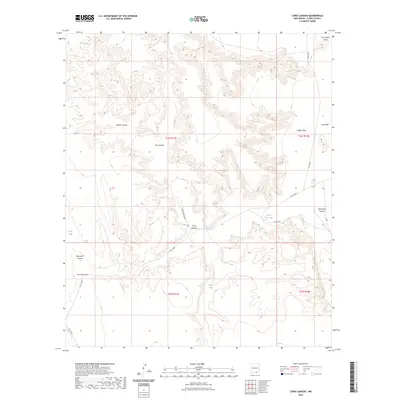
2023 Map of Lewis Canyon
USGS Topo · Published 2023About this map
Lewis Canyon and the surrounding drainage networks of Otero County define this high-desert landscape in southeastern New Mexico. The terrain is deeply incised by seasonal watercourses such as Willow Canyon, Hay Canyon, and the appropriately named Fourmile Draw. These features demonstrate a classic southwestern erosion pattern where canyons and draws lead toward more level ground at Crow Flats.
Find a feature on this map
20 named features on this map. Tap any name to fly to it.
Don’t see what you’re looking for? This feature index may not catch every label — zoom into the map to look around manually.
Map Details
Editions of this 2023 Lewis Canyon Map
This is the sole edition of this map. No revisions or reprints were ever made.
Other maps of this area

1954 · Carlsbad
USGS Topo · 1:250,000

1958 · Carlsbad
USGS Topo · 1:250,000

1963 · Hackberry Hill
USGS Topo · 1:24,000
1963 · Cornucopia Ranch SE
USGS Topo · 1:24,000

1963 · Gowdy Ranch
USGS Topo · 1:24,000

1969 · Lewis Canyon
USGS Topo · 1:24,000
1969 · Sheep Draw
USGS Topo · 1:24,000
1969 · Cienega School
USGS Topo · 1:24,000
1969 · Culp Draw
USGS Topo · 1:24,000
1970 · Shiloh Hills SE
USGS Topo · 1:24,000