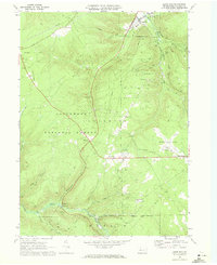
1969 Map of Lewis Run
USGS Topo · Published 1972About this map
Marshburg Oil Field, Lewis Run Oil Field, and Guffey Oil Field define the industrial character of this region in the late 1960s, with dozens of active oil and gas wells scattered across the plateau. The landscape is a mix of extractive industry and conserved wilderness, as large portions of the Allegheny National Forest intersect with the township boundaries of Lafayette and Hamlin. High-elevation landmarks like Music Mountain and Big Shanty Hill rise above the drainage of Tunuangwant Creek and Wintergreen Run.
Find a feature on this map
42 named features on this map. Tap any name to fly to it.
Don’t see what you’re looking for? This feature index may not catch every label — zoom into the map to look around manually.
Map Details
Editions of this 1969 Lewis Run Map
Other maps of this area

1924 · Bradford
USGS Topo · 1:62,500

1926 · Bradford
USGS Topo · 1:62,500

1934 · Kane
USGS Topo · 1:48,000

1935 · Mt. Jewett
USGS Topo · 1:48,000

1936 · Kinzua
USGS Topo · 1:48,000

1939 · Kane
USGS Topo · 1:62,500

1940 · Mt. Jewett
USGS Topo · 1:62,500

1941 · Kinzua
USGS Topo · 1:62,500

1941 · Bradford
USGS Topo · 1:62,500

1944 · Bradford
USGS Topo · 1:62,500
Featured Places
- Lafayette Township, PA
- Lewis Run, PA
- Taintor, Lafayette Township
- Big Shanty, Lafayette Township
- Riterville, Lafayette Township