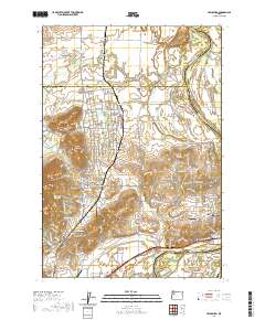
2020 Map of Lewisburg
USGS Topo · Published 2020About this map
Adair Village and the rural outskirts of Albany anchor this landscape along the border of Polk, Benton, and Linn counties. The map illustrates a transition from the agricultural lowlands of the Willamette River to the prominent rises of Coffin Butte and Poison Oak Hill. This area serves as a focal point for local history and genealogy, containing several significant burying grounds including Ridders Pioneer Cem, Gingles Cem, and the Locke Cem. The settlement pattern is defined by a network of historic routes like Old Pacific Hwy and Military Rd, which connect smaller communities like Suver and Lewisburg. Water management is central to the terrain, evidenced by features such as the Frazier Cr Ditch, Bowers Slough, and the expansive Bryant Lake Bed near the junction of the Calapooia River. Small-scale aviation is also prominent, with Flying Tom Airport and Gates Airport serving the local rural community.
Find a feature on this map
100 named features on this map. Tap any name to fly to it.
Don’t see what you’re looking for? This feature index may not catch every label — zoom into the map to look around manually.
Map Details
Editions of this 2020 Lewisburg Map
This is the sole edition of this map. No revisions or reprints were ever made.
Other maps of this area

1911 · Tangent
USGS Topo · 1:31,680

1912 · Jefferson
USGS Topo · 1:31,680

1913 · Philomath
USGS Topo · 1:31,680

1913 · Oakville
USGS Topo · 1:31,680

1913 · Wells
USGS Topo · 1:31,680

1914 · Independence
USGS Topo · 1:31,680

1914 · Soap Creek
USGS Topo · 1:31,680

1915 · Sidney
USGS Topo · 1:31,680

1916 · Albany
USGS Topo · 1:62,500

1917 · Salem
USGS Topo · 1:62,500