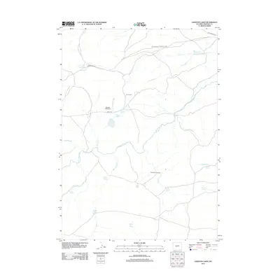
2012 Map of Lewiston Lakes
USGS Topo · Published 2012About this map
The Oregon Trl cuts across this high-plains landscape in Fremont County, marking a corridor of historical transit that defined the American West. Centered near Lewiston Lakes, the terrain is a network of riparian corridors and seasonal water sources essential for cattle ranching and early travel. Named springs like Immigrant Springs, Wagon Tire Spring, and Lower Mormon Spring highlight the critical importance of water for those crossing this arid region. The map shows the intersection of these traditional routes with livestock management sites such as the Yellowstone Cow Camp and Canoys Cabin near McLean Meadows. The presence of the Arnold Ditch Number 1 and Silver Creek Reservoir reflects later efforts to manage the Sweetwater River watershed for agricultural use, while the Fort Stambaugh-Atlantic City Rd further illustrates the established network of mountain-to-basin connectivity.
Find a feature on this map
28 named features on this map. Tap any name to fly to it.
Don’t see what you’re looking for? This feature index may not catch every label — zoom into the map to look around manually.
Map Details
Editions of this 2012 Lewiston Lakes Map
This is the sole edition of this map. No revisions or reprints were ever made.
Other maps of this area

1953 · Lewiston Lakes
USGS Topo · 1:24,000

1953 · Barras Springs
USGS Topo · 1:24,000

1953 · Gravel Spring
USGS Topo · 1:24,000

1953 · Radium Springs
USGS Topo · 1:24,000

1953 · Schlichting Mountain
USGS Topo · 1:24,000

1953 · Red Canyon
USGS Topo · 1:24,000

1955 · Lander
USGS Topo · 1:250,000
1957 · Red Canyon
USGS Topo · 1:24,000

1958 · Lander
USGS Topo · 1:250,000
1958 · Schoettlin Mountain
USGS Topo · 1:24,000