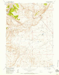
1957 Map of Red Canyon
USGS Topo · Published 1958About this map
Beaver Rim dominates the landscape of this 1950s Wyoming survey, creating a dramatic escarpment that separates the high desert plateau from the drainage basins of Red Canyon and Cottonwood Creek. This portion of Fremont County is defined by its seasonal water sources and the historic tracks of the Oregon Trail, which cuts across the southeastern quadrant. The presence of ranching infrastructure, such as the Antelope Springs Reservoir and Jackson Reservoir, points to the long-standing importance of water management in this arid cattle country. Notable topographic landmarks include Butte 7300 and Pass 6958, while numerous drainage draws like Soap Hole Draw and Rocky Draw illustrate the erosional patterns of the local geology. Historians can trace the exact route of early pioneers as it coincides with the natural corridors provided by Little Antelope Creek and other nearby springs.
Find a feature on this map
17 named features on this map. Tap any name to fly to it.
Don’t see what you’re looking for? This feature index may not catch every label — zoom into the map to look around manually.
Map Details
Editions of this 1957 Red Canyon Map
3 editions found
Other maps of this area

1953 · Lewiston Lakes
USGS Topo · 1:24,000

1953 · Barras Springs
USGS Topo · 1:24,000

1953 · Sweetwater Station
USGS Topo · 1:24,000

1953 · Happy Spring
USGS Topo · 1:24,000

1953 · Schlichting Mountain
USGS Topo · 1:24,000

1953 · Dishpan Butte
USGS Topo · 1:24,000

1953 · Del Monte Ridge
USGS Topo · 1:24,000

1953 · Yellowstone Ranch
USGS Topo · 1:24,000

1953 · Red Canyon
USGS Topo · 1:24,000

1955 · Lander
USGS Topo · 1:250,000