
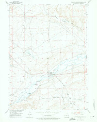
1953 Map of Sweetwater Station
USGS Topo · Published 1954About this map
The Sweetwater River meanders across this Fremont County landscape, carving a fertile valley through the arid terrain of central Wyoming in the early 1950s. This survey highlights a critical intersection of western history and local agriculture, where the historic route of the Oregon Trail runs parallel to the river and modern livestock operations. Family-named landmarks such as Countryman Ranch, Flagg Ranch, and Jamerman Ranch define the settlement pattern, anchored by the namesake hub at Sweetwater Station. A complex network of irrigation channels, including the Independent Ditch and the Farmsley and Farmsley Ditch, illustrates the engineering efforts required to sustain ranching in the Bison Basin area. Further north, isolated features like Carmody Lake and the Slide Windmill mark the open range of this high-plateau environment.
Find a feature on this map
28 named features on this map. Tap any name to fly to it.
Don’t see what you’re looking for? This feature index may not catch every label — zoom into the map to look around manually.
Map Details
Editions of this 1953 Sweetwater Station Map
2 editions found
Other maps of this area

1951 · Soap Holes
USGS Topo · 1:24,000

1951 · Myers Ranch
USGS Topo · 1:24,000

1953 · Barras Springs
USGS Topo · 1:24,000

1953 · Happy Spring
USGS Topo · 1:24,000

1953 · Elkhorn Springs
USGS Topo · 1:24,000

1953 · Dishpan Butte
USGS Topo · 1:24,000

1953 · Yellowstone Ranch
USGS Topo · 1:24,000

1953 · Red Canyon
USGS Topo · 1:24,000

1955 · Lander
USGS Topo · 1:250,000
1957 · Red Canyon
USGS Topo · 1:24,000