
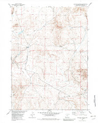
1953 Map of Elkhorn Springs
USGS Topo · Published 1954About this map
Beaver Rim and the Granite Mountains define the high-desert character of this Fremont County landscape during the early 1950s. The area was mapped as part of a Department of the Interior program focused on developing the Missouri River Basin, revealing a transition from open grazing land to early industrial exploration. Modern infrastructure is evident in the presence of a Pipe Line and a prominent Gas Well located south of Findlay Lake. This period of topographic surveying caught the region just as resource extraction began to overlay the older natural hydrology of the West Fork and Long Creek drainage systems. Isolated landmarks like Elkhorn Springs provided vital water points for cattle and wildlife in an otherwise arid expanse marked by the sharp topography of Cedar Rim Draw.
Find a feature on this map
13 named features on this map. Tap any name to fly to it.
Don’t see what you’re looking for? This feature index may not catch every label — zoom into the map to look around manually.
Map Details
Editions of this 1953 Elkhorn Springs Map
2 editions found
Other maps of this area

1951 · Graham Ranch
USGS Topo · 1:24,000

1951 · Myers Ranch
USGS Topo · 1:24,000

1952 · Tin Cup Mountain
USGS Topo · 1:24,000

1952 · Rongis Reservoir
USGS Topo · 1:24,000

1953 · Blue Gulch
USGS Topo · 1:24,000

1953 · Sweetwater Station
USGS Topo · 1:24,000

1953 · Sand Draw
USGS Topo · 1:24,000

1953 · Dishpan Butte
USGS Topo · 1:24,000

1955 · Lander
USGS Topo · 1:250,000

1955 · Casper
USGS Topo · 1:250,000