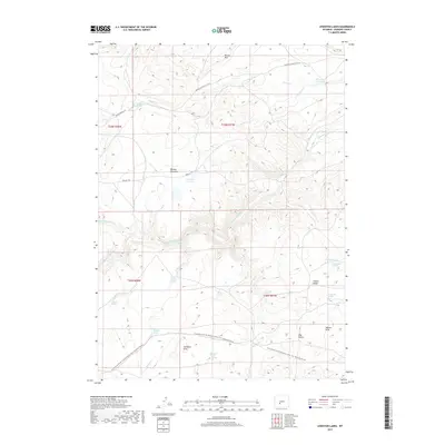
2017 Map of Lewiston Lakes
USGS Topo · Published 2017About this map
The Oregon Trl cuts across this high desert landscape, marking the historic path of westward expansion through the rugged heart of Fremont County. This modern survey illustrates the layered history of the region, where the original emigrant route is now paralleled by the Continental Divide National Scenic Trail. The terrain is defined by the steep escarpment of Beaver Rim to the north and the rolling Antelope Hills to the south. Water management and survival are central themes, evidenced by early irrigation works like Arnold Ditch Number 1 and numerous named water sources including Lower Mormon Spring, Immigrant Springs, and Wagon Tire Spring. The Sweetwater River and its tributaries, such as Strawberry Cr and Chimney Cr, provide the lifeblood for this arid environment, while McLean Meadows and Lewiston Lakes offer rare patches of level ground and seasonal water storage.
Find a feature on this map
35 named features on this map. Tap any name to fly to it.
Don’t see what you’re looking for? This feature index may not catch every label — zoom into the map to look around manually.
Map Details
Editions of this 2017 Lewiston Lakes Map
This is the sole edition of this map. No revisions or reprints were ever made.
Other maps of this area

1953 · Lewiston Lakes
USGS Topo · 1:24,000

1953 · Barras Springs
USGS Topo · 1:24,000

1953 · Gravel Spring
USGS Topo · 1:24,000

1953 · Radium Springs
USGS Topo · 1:24,000

1953 · Schlichting Mountain
USGS Topo · 1:24,000

1953 · Red Canyon
USGS Topo · 1:24,000

1955 · Lander
USGS Topo · 1:250,000
1957 · Red Canyon
USGS Topo · 1:24,000

1958 · Lander
USGS Topo · 1:250,000
1958 · Schoettlin Mountain
USGS Topo · 1:24,000