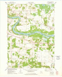
1975 Map of Lewiston
USGS Topo · Published 1978About this map
The Wisconsin River creates a sweeping curve through the center of this mid-1970s landscape, serving as the border between Sauk and Columbia counties. This corridor is defined by the heavy infrastructure of the Chicago Milwaukee St Paul and Pacific railroad and a network of rural crossroads. Local life is anchored by small settlements like Lewiston, Newport, and Pecks Corners, while the southern portion of the map is dominated by the rise of the Baraboo Range. Notable cultural landmarks of the era include a Drive-in Theater near the river and several cemeteries, such as Hillcrest Cem and Fairfield Cem, which offer significant value for genealogists. The presence of the Fairfield Center Sch and the Townhall indicates the civic centers of these farming townships during the transition of the late twentieth century.
Find a feature on this map
47 named features on this map. Tap any name to fly to it.
Don’t see what you’re looking for? This feature index may not catch every label — zoom into the map to look around manually.
Map Details
Editions of this 1975 Lewiston Map
This is the sole edition of this map. No revisions or reprints were ever made.
Other maps of this area

1895 · Baraboo
USGS Topo · 1:62,500

1901 · Denzer
USGS Topo · 1:62,500

1901 · The Dells
USGS Topo · 1:62,500

1902 · Briggsville
USGS Topo · 1:62,500

1908 · Baraboo
USGS Topo · 1:62,500

1957 · Wisconsin Dells
USGS Topo · 1:62,500

1957 · Madison
USGS Topo · 1:250,000

1958 · Briggsville
USGS Topo · 1:62,500

1958 · North Freedom
USGS Topo · 1:62,500

1959 · Baraboo
USGS Topo · 1:62,500