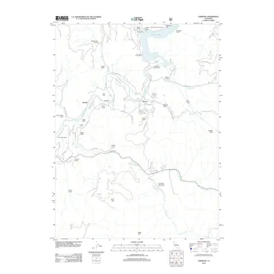
2012 Map of Lewiston
USGS Topo · Published 2012About this map
The Trinity River and its managed hydrology define this portion of Trinity County, where the river's flow is punctuated by the Trinity River Fish Hatchery and the Clear Creek Tunnel. The community of Lewiston serves as the central hub, surrounded by a landscape marked by legacy landholdings and small settlements such as Lowden Ranch, Gold Bar, and Fawn Lodge. The terrain is characterized by a dense network of gulches—including Alder Gulch, Dark Gulch, and Jennings Gulch—that drain the surrounding high ground of Hoadley Peaks and Tylers Peak.
Find a feature on this map
61 named features on this map. Tap any name to fly to it.
Don’t see what you’re looking for? This feature index may not catch every label — zoom into the map to look around manually.
Map Details
Editions of this 2012 Lewiston Map
This is the sole edition of this map. No revisions or reprints were ever made.
Other maps of this area

1890 · Red Bluff
USGS Topo · 1:250,000

1894 · Red Bluff
USGS Topo · 1:250,000

1913 · Weaverville
USGS Topo · 1:125,000

1944 · French Gulch
USGS Topo · 1:62,500

1948 · French Gulch
USGS Topo · 1:62,500

1950 · Minersville
USGS Topo · 1:62,500

1950 · Schell Mtn
USGS Topo · 1:62,500

1950 · Weaverville
USGS Topo · 1:62,500
1952 · Schell Mtn.
USGS Topo · 1:62,500

1952 · Weaverville
USGS Topo · 1:62,500