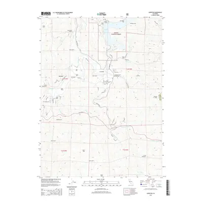
2015 Map of Lewiston
USGS Topo · Published 2015About this map
The Trinity River winds through this Northern California landscape, dominated by the waters of Lewiston Lake and the rugged heights of the Trinity National Forest. The community of Lewiston serves as the central hub, surrounded by narrow gulches and family-named landmarks like Jennings Gulch and Jessup Gulch. Notable industrial and topographical features include the Clear Creek Tunnel and several prominent summits such as Tylers Peak and Mikes Peak. The settlement of Bucktail and the riverside area of Gold Bar reflect the regional focus on the river valley's resources. Tracing the numerous gulches like Dead Mule Gulch and Sawmill Gulch reveals a complex network of canyons that have defined local transport and land use for generations.
Find a feature on this map
72 named features on this map. Tap any name to fly to it.
Don’t see what you’re looking for? This feature index may not catch every label — zoom into the map to look around manually.
Map Details
Editions of this 2015 Lewiston Map
This is the sole edition of this map. No revisions or reprints were ever made.
Other maps of this area

1890 · Red Bluff
USGS Topo · 1:250,000

1894 · Red Bluff
USGS Topo · 1:250,000

1913 · Weaverville
USGS Topo · 1:125,000

1944 · French Gulch
USGS Topo · 1:62,500

1948 · French Gulch
USGS Topo · 1:62,500

1950 · Minersville
USGS Topo · 1:62,500

1950 · Schell Mtn
USGS Topo · 1:62,500

1950 · Weaverville
USGS Topo · 1:62,500
1952 · Schell Mtn.
USGS Topo · 1:62,500

1952 · Weaverville
USGS Topo · 1:62,500