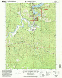
1998 Map of Lewiston
USGS Topo · Published 2003About this map
The town of Lewiston serves as the central hub of this northern California landscape, situated where the Trinity River continues its course south of the Lewiston Lake impoundment. This late-twentieth-century revision, updated by the USDA Forest Service, reveals a region defined by its managed water resources and recreational infrastructure. The lake’s northern reaches are marked by the Lakeview Terrace Resort, while the surrounding terrain is deeply incised by numerous drainages such as Baker Gulch, Cooper Gulch, and Jennings Gulch. The mapping reflects a period of established forest management and developed public access within the National Forest System. Significant tributary action is evident where Rush Creek joins the main river valley, illustrating the complex hydrology that supports the area's local economy and natural environment.
Find a feature on this map
10 named features on this map. Tap any name to fly to it.
Don’t see what you’re looking for? This feature index may not catch every label — zoom into the map to look around manually.
Map Details
Editions of this 1998 Lewiston Map
This is the sole edition of this map. No revisions or reprints were ever made.
Other maps of this area

1890 · Red Bluff
USGS Topo · 1:250,000

1894 · Red Bluff
USGS Topo · 1:250,000

1913 · Weaverville
USGS Topo · 1:125,000

1944 · French Gulch
USGS Topo · 1:62,500

1948 · French Gulch
USGS Topo · 1:62,500

1950 · Minersville
USGS Topo · 1:62,500

1950 · Schell Mtn
USGS Topo · 1:62,500

1950 · Weaverville
USGS Topo · 1:62,500
1952 · Schell Mtn.
USGS Topo · 1:62,500

1952 · Weaverville
USGS Topo · 1:62,500