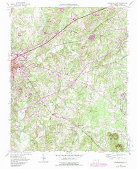
1950 Map of Lexington East
USGS Topo · Published 1987About this map
The eastern expansion of Lexington is documented here as it moved into the rolling countryside of central Davidson County. This 1950 landscape, updated in 1987, is defined by the heavy infrastructure of the Southern railroad and the Radio Tower (WBUY) standing over a network of rural communities. The map captures a high density of local institutions, including Pilgrim Ch, Mt Tabor Ch, and the distinct Old Beeks Ch and New Beeks Ch, which offer significant value for genealogists tracing family ties in the region.
Find a feature on this map
29 named features on this map. Tap any name to fly to it.
Don’t see what you’re looking for? This feature index may not catch every label — zoom into the map to look around manually.
Map Details
Editions of this 1950 Lexington East Map
4 editions found
Other maps of this area

1949 · Denton NW
USGS Topo · 1:24,000

1949 · Eller
USGS Topo · 1:24,000

1949 · High Point West
USGS Topo · 1:24,000

1950 · Lexington East
USGS Topo · 1:24,000

1950 · Lexington West
USGS Topo · 1:24,000

1951 · Lexington East
USGS Topo · 1:24,000

1951 · Lexington West
USGS Topo · 1:24,000

1951 · Fair Grove
USGS Topo · 1:24,000

1953 · Charlotte
USGS Topo · 1:250,000

1954 · Charlotte
USGS Topo · 1:250,000