1929 Map of Lexington
USGS Topo · Published 1943About this map
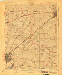
Lexington and the surrounding Bluegrass region appear at a height of rail and road interconnectivity in this late 1920s survey. The landscape is dominated by a dense network of pikes, such as the Ironworks Pike and Russell Cave Pike, which radiate from the urban core toward outlying settlements like Paris and Clintonville. This era reveals the specialized infrastructure of horse country and rural commerce, including the Kentucky Traction and Terminal Co electric line and the Chesapeake and Ohio railroad. Geologic and genealogical interests converge at landmarks like Russell Cave and Bryant Sta Sprs, while dozens of localized schools and churches, including Beatty Sch and Antioch Ch, serve as anchors for small communities. The map captures the agricultural heart of the Commonwealth before modern suburban expansion began to reorganize these family-named holdings and rural junctions.
Find a feature on this map
85 named features on this map. Tap any name to fly to it.
Don’t see what you’re looking for? This feature index may not catch every label — zoom into the map to look around manually.
Map Details
Editions of this 1929 Lexington Map
2 editions found

Historical Maps of Lexington Through Time
3 maps found

