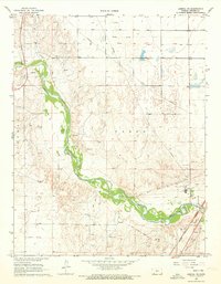
1968 Map of Liberal NE
USGS Topo · Published 1973About this map
The Cimarron River carves a deep, winding valley through the high plains of Seward County, creating a stark contrast between the riparian breaks and the flat uplands of Liberal and Fargo townships. The settlement of Arkalon is situated near the riverbanks, supported by the Arkalon Cem to the south. This area serves as a significant energy and transit corridor, evidenced by numerous Gas Wells and a large industrial Refinery at the eastern edge of the map. Transportation history is etched into the landscape through the Chicago Rock Island and Pacific railroad line and an Old Railroad Grade that mirrors the river's path. Infrastructure for the mid-century energy economy is further represented by a complex network of Pipelines and several Gravel Pits that suggest ongoing local construction and maintenance during the late 1960s.
Find a feature on this map
14 named features on this map. Tap any name to fly to it.
Don’t see what you’re looking for? This feature index may not catch every label — zoom into the map to look around manually.
Map Details
Editions of this 1968 Liberal NE Map
3 editions found
Other maps of this area

1955 · Dodge City
USGS Topo · 1:250,000

1958 · Dodge City
USGS Topo · 1:250,000

1959 · Dodge City
USGS Topo · 1:250,000

1968 · Plains SW
USGS Topo · 1:24,000

1968 · Sublette SW
USGS Topo · 1:24,000

1968 · Liberal NE
USGS Topo · 1:24,000

1968 · Sublette SE
USGS Topo · 1:24,000

1968 · Liberal NW
USGS Topo · 1:24,000

1971 · Liberal
USGS Topo · 1:24,000
1971 · Kismet
USGS Topo · 1:24,000