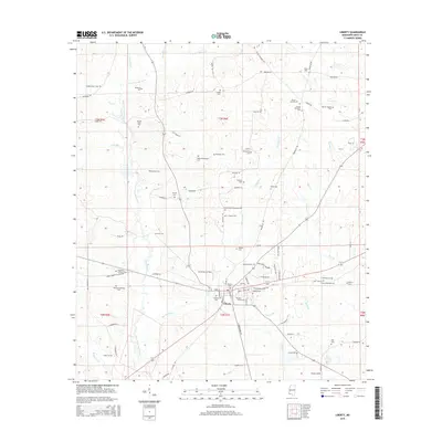
2015 Map of Liberty
USGS Topo · Published 2015About this map
Liberty serves as the focal point of this Amite County survey, situated where numerous local routes like Main St and Old McComb Liberty Rd converge. The landscape is heavily marked by family-named burial sites, such as the Stubbs-Carter Cem and Webb-Whittington Cem, providing a detailed record for genealogical research. The region's geography is defined by the branching paths of the West Fork Amite River and its many tributaries, including Zion Hill Cr and Speculation Cr.
Find a feature on this map
99 named features on this map. Tap any name to fly to it.
Don’t see what you’re looking for? This feature index may not catch every label — zoom into the map to look around manually.
Map Details
Editions of this 2015 Liberty Map
This is the sole edition of this map. No revisions or reprints were ever made.
Other maps of this area

1953 · Natchez
USGS Topo · 1:250,000

1956 · Natchez
USGS Topo · 1:250,000

1959 · Natchez
USGS Topo · 1:250,000

1961 · Liberty
USGS Topo · 1:62,500

1962 · Bude
USGS Topo · 1:62,500

1972 · Smithdale
USGS Topo · 1:24,000

1972 · Peoria
USGS Topo · 1:24,000
1972 · Gillsburg
USGS Topo · 1:24,000

1984 · McComb
USGS Topo · 1:100,000
1988 · Homochitto
USGS Topo · 1:24,000