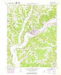
1952 Map of Liberty
USGS Topo · Published 1979About this map
The Green River winds through the heart of Casey County, anchoring the town of Liberty during a period of mid-century development. This landscape is defined by its deep community roots, evidenced by a dense network of local institutions such as Hopewell Sch, Cainey Fork Sch, and the Poplar Springs Ch. The town of Liberty serves as the central hub, featuring the Glenwood Cem and even a modern drive-in theatre on its outskirts, signaling the shift toward post-war car culture.
Find a feature on this map
58 named features on this map. Tap any name to fly to it.
Don’t see what you’re looking for? This feature index may not catch every label — zoom into the map to look around manually.
Map Details
Editions of this 1952 Liberty Map
2 editions found
Other maps of this area

1952 · Ellisburg
USGS Topo · 1:24,000

1952 · Hustonville
USGS Topo · 1:24,000

1952 · Clementsville
USGS Topo · 1:24,000

1952 · Liberty
USGS Topo · 1:24,000

1952 · Yosemite
USGS Topo · 1:24,000

1953 · Bradfordsville NE
USGS Topo · 1:24,000

1953 · Phil
USGS Topo · 1:24,000

1953 · Mintonville
USGS Topo · 1:24,000

1953 · Dunnville
USGS Topo · 1:24,000

1957 · Winchester
USGS Topo · 1:250,000