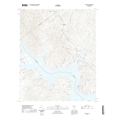
2020 Map of Liberty Hill
USGS Topo · Published 2020About this map
Liberty Hill sits at the northern end of this survey, where the rolling uplands of Kershaw County meet the intricate shoreline of Wateree Lake. The landscape is defined by the convergence of several major drainage systems, including the southward-flowing Singleton Cr and Beaver Cr, which feed into the large reservoir. For those researching local family history, the map documents several important landmarks such as the Summerville - Cunningham Cem and New Grove Cem, along with the Mineral Spring and Hilton House Pond. The jagged boundary line between Lancaster, Kershaw, and Fairfield counties intersects here, following the natural course of the water. The extensive network of local roads, such as John G Richards Rd and State Rd S-28-840, illustrates the modern connectivity of this lakefront community while preserving the names of early family landholdings and geographical features like Rochelle Cr.
Find a feature on this map
66 named features on this map. Tap any name to fly to it.
Don’t see what you’re looking for? This feature index may not catch every label — zoom into the map to look around manually.
Map Details
Editions of this 2020 Liberty Hill Map
This is the sole edition of this map. No revisions or reprints were ever made.
Other maps of this area

1935 · Camden
USGS Topo · 1:48,000

1938 · Camden
USGS Topo · 1:62,500

1941 · Spartanburg
USGS Topo · 1:250,000

1942 · Camden
USGS Topo · 1:125,000

1953 · Spartanburg
USGS Topo · 1:250,000

1960 · Spartanburg
USGS Topo · 1:250,000

1963 · Spartanburg
USGS Topo · 1:250,000

1964 · Spartanburg
USGS Topo · 1:250,000

1968 · Lancaster SE
USGS Topo · 1:24,000

1968 · Heath Springs
USGS Topo · 1:24,000