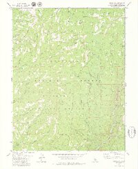
1979 Map of Liberty Hill
USGS Topo · Published 1979About this map
Liberty Hill stands as a prominent landmark in this high-altitude landscape of the Stanislaus National Forest, where the terrain is defined by a dense network of mountain meadows and seasonal drainages. During the late 1970s, this area of Tuolumne County remained largely primitive, characterized by its reliance on a system of Pack Trails and jeep tracks rather than paved infrastructure. The presence of Post Corral and Snyder Camp suggests the enduring seasonal use of the high country for livestock or forest management. To the southeast, the Middle Fork Stanislaus River carves through the landscape, marked by a series of Rapids and the Cascade Falls. This map captures a moment when the natural contours of the land, from Big Prather Meadow to the rocky Dardanelles, dictated the movement of people and industry, including a localized Quarry near the river's edge.
Find a feature on this map
46 named features on this map. Tap any name to fly to it.
Don’t see what you’re looking for? This feature index may not catch every label — zoom into the map to look around manually.
Map Details
Editions of this 1979 Liberty Hill Map
3 editions found
Other maps of this area

1891 · Big Trees
USGS Topo · 1:125,000

1894 · Big Trees
USGS Topo · 1:125,000

1896 · Dardanelles
USGS Topo · 1:125,000

1897 · Big Trees
USGS Topo · 1:125,000

1898 · Dardanelles
USGS Topo · 1:125,000

1901 · Big Trees
USGS Topo · 1:125,000

1947 · Sacramento
USGS Topo · 1:250,000

1948 · Walker Lake
USGS Topo · 1:250,000

1948 · Sacramento
USGS Topo · 1:250,000

1956 · Sacramento
USGS Topo · 1:250,000