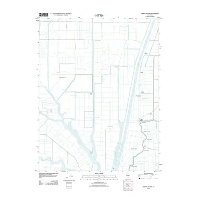
2012 Map of Liberty Island
USGS Topo · Published 2012About this map
Liberty Island and Prospect Island anchor this hydrographic landscape of the Sacramento River Delta, where a complex network of sloughs and cuts facilitates both drainage and navigation. The Sacramento River Deep Water Ship Channel dominates the eastern corridor, flanked by the Toe Drain and Liberty Cut. This 2012 survey illustrates the region's heavy reliance on water-borne transport and agricultural infrastructure, evidenced by numerous historical docking points like Chicory Wharf, Kidder Landing, and Lents Landing along Miner Slough. Inland, the economy shifts toward energy extraction at the Millar Gas Field and Maine Prairie Gas Field. Small agricultural clusters such as Lund, Daisie, and Liberty Farms are connected by a grid of rural roads, including Liberty Island Rd and Co Rd 104, which navigate the low-lying terrain between Cache Slough and Shag Slough.
Find a feature on this map
54 named features on this map. Tap any name to fly to it.
Don’t see what you’re looking for? This feature index may not catch every label — zoom into the map to look around manually.
Map Details
Editions of this 2012 Liberty Island Map
This is the sole edition of this map. No revisions or reprints were ever made.
Other maps of this area

1907 · Antioch
USGS Topo · 1:62,500

1908 · Vacaville
USGS Topo · 1:62,500

1908 · Courtland
USGS Topo · 1:62,500

1908 · Antioch
USGS Topo · 1:62,500

1910 · Rio Vista
USGS Topo · 1:31,680

1910 · Isleton
USGS Topo · 1:31,680

1916 · Dixon
USGS Topo · 1:31,680

1916 · Cache Slough
USGS Topo · 1:31,680

1916 · Vorden
USGS Topo · 1:31,680

1916 · Maine Prairie
USGS Topo · 1:31,680