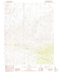
1987 Map of Lida Wash SW
USGS Topo · Published 1987About this map
Silver Peak Range and the Palmetto Mountains converge in this high-desert landscape, where the jagged topography drops sharply northward toward the flat expanse of Clayton Valley. Mapping here focuses heavily on the extractive history of Esmeralda County, revealing a network of rugged 4wd tracks that provided the only access to numerous remote workings. While no large-scale towns are present, the map is dotted with individual mining features, including several prospects and an isolated Mine, reflecting the persistent mineral exploration characteristic of this region in the late twentieth century. Surveyed in the mid-1980s, the document illustrates a transition from the mountainous peaks down to the alkali basin floor, preserving the exact layout of the primitive road system used by surveyors and prospectors alike.
Find a feature on this map
9 named features on this map. Tap any name to fly to it.
Don’t see what you’re looking for? This feature index may not catch every label — zoom into the map to look around manually.
Map Details
Editions of this 1987 Lida Wash SW Map
This is the sole edition of this map. No revisions or reprints were ever made.
Other maps of this area

1898 · Silver Peak
USGS Topo · 1:125,000

1900 · Silver Peak
USGS Topo · 1:125,000

1908 · Lida
USGS Topo · 1:250,000

1913 · Lida
USGS Topo · 1:250,000

1954 · Goldfield
USGS Topo · 1:250,000

1955 · Goldfield
USGS Topo · 1:250,000

1957 · Magruder Mtn
USGS Topo · 1:62,500

1958 · Goldfield
USGS Topo · 1:250,000

1958 · Soldier Pass
USGS Topo · 1:62,500

1962 · Goldfield
USGS Topo · 1:250,000