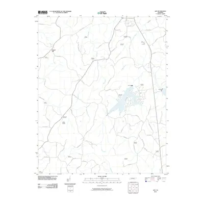
2010 Map of Life
USGS Topo · Published 2010About this map
Chapel Hill anchors the northwest corner of this Henderson County landscape, where a dense network of country roads connects decades of family homesteads and rural landmarks. The terrain is defined by the winding paths of Wolf Creek and Middle Fork Creek, which feed into the larger hydrological system including the Beech River. This survey reveals a high concentration of small, family-named burial grounds, such as Mullins Cemetery and the County Farm Cemetery, offering significant value for genealogical research. The presence of Pine Dam and Sycamore Dam illustrates the mid-century water management efforts in the region. Along the southern reaches, the mapping of Jacks Creek and smaller tributaries like Goff Branch highlights the agricultural drainage patterns that shaped local land use and property boundaries during this era of Tennessee history.
Find a feature on this map
70 named features on this map. Tap any name to fly to it.
Don’t see what you’re looking for? This feature index may not catch every label — zoom into the map to look around manually.
Map Details
Editions of this 2010 Life Map
This is the sole edition of this map. No revisions or reprints were ever made.
Other maps of this area

1936 · Lexington
USGS Topo · 1:24,000

1936 · Sardis
USGS Topo · 1:24,000

1936 · Reagan
USGS Topo · 1:24,000

1936 · Enville
USGS Topo · 1:24,000

1936 · Life
USGS Topo · 1:24,000

1936 · Chesterfield
USGS Topo · 1:24,000
1949 · Sardis
USGS Topo · 1:24,000

1950 · Reagan
USGS Topo · 1:24,000

1950 · Life
USGS Topo · 1:24,000

1950 · Enville
USGS Topo · 1:24,000