
1950 Map of Reagan
USGS Topo · Published 1952About this map
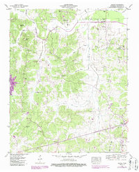
Reagan and the surrounding Henderson County uplands are documented here during a period of agricultural and hydrologic transition. The landscape is defined by the Beech River and its complex drainage network, including the Beech River Slough and the Cane Creek Canal. The presence of a Dismantled RR in the northern portion of the map near Warrens Bluff points to a shift in regional transport, as older rail lines gave way to the improving road network seen around Middleburg and Scotts Hill.
Find a feature on this map
61 named features on this map. Tap any name to fly to it.
Don’t see what you’re looking for? This feature index may not catch every label — zoom into the map to look around manually.
Map Details
Editions of this 1950 Reagan Map
2 editions found
Other maps of this area

1936 · Lexington
USGS Topo · 1:24,000

1936 · Scotts Hill
USGS Topo · 1:24,000

1936 · Parsons
USGS Topo · 1:24,000

1936 · Thurman
USGS Topo · 1:24,000

1936 · Sardis
USGS Topo · 1:24,000

1936 · Reagan
USGS Topo · 1:24,000

1936 · Enville
USGS Topo · 1:24,000

1936 · Life
USGS Topo · 1:24,000

1936 · Chesterfield
USGS Topo · 1:24,000
1949 · Sardis
USGS Topo · 1:24,000