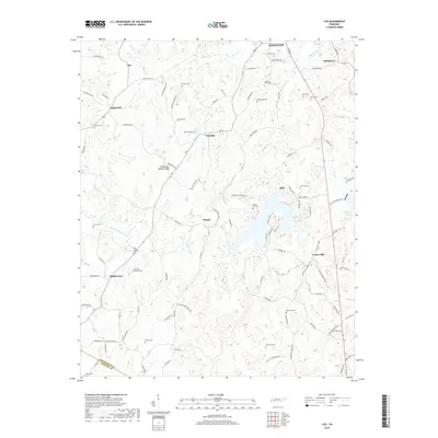
2019 Map of Life
USGS Topo · Published 2019About this map
The Tennessee Valley Divide snakes through this portion of Henderson County, separating the drainage of Wolf Cr and the Beech River from the southern watersheds. This landscape is defined by its small, traditional communities such as Palestine, Stegall, and the eponymous Life. The map reveals a dense concentration of family and community burial grounds, including the County Farm Cem and Macedonia Cem south of Lexington, which provide critical reference points for genealogists. Water is a central feature here, from the engineered Sycamore Lake to the natural winding course of Middle Fork Cr. The road network, with names like Laster School Rd and Jacks Creek Church Rd, hints at the historical locations of civic and religious centers that once anchored these rural crossroads.
Find a feature on this map
107 named features on this map. Tap any name to fly to it.
Don’t see what you’re looking for? This feature index may not catch every label — zoom into the map to look around manually.
Map Details
Editions of this 2019 Life Map
This is the sole edition of this map. No revisions or reprints were ever made.
Other maps of this area

1936 · Lexington
USGS Topo · 1:24,000

1936 · Sardis
USGS Topo · 1:24,000

1936 · Reagan
USGS Topo · 1:24,000

1936 · Enville
USGS Topo · 1:24,000

1936 · Life
USGS Topo · 1:24,000

1936 · Chesterfield
USGS Topo · 1:24,000
1949 · Sardis
USGS Topo · 1:24,000

1950 · Reagan
USGS Topo · 1:24,000

1950 · Life
USGS Topo · 1:24,000

1950 · Enville
USGS Topo · 1:24,000