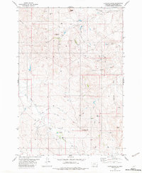
1982 Map of Lightning Butte
USGS Topo · Published 1982About this map
Lightning Butte and its surrounding rangelands in the Powder River country are defined by a complex network of draws and intermittent drainages that shaped the ranching landscape of the early 1980s. The topography is anchored by prominent landmarks like Buffalo Butte, Shipley Butte, and Pine Butte, which served as essential orientation points in this remote corner of Montana. Water management is a central theme of the map, evidenced by man-made catchments such as Vannett Reservoir, Moody Res, and the notably named CCC Res, a likely legacy of Civilian Conservation Corps projects. The presence of a Landing Strip and multiple Drill Hole markers suggests a mix of private aviation and resource exploration. Winding coulees like Ainsworth Coulee and the branching paths of Williams Butte Creek create a deeply dissected terrain where springs and wells provide the lifeblood for cattle and wildlife.
Find a feature on this map
27 named features on this map. Tap any name to fly to it.
Don’t see what you’re looking for? This feature index may not catch every label — zoom into the map to look around manually.
Map Details
Editions of this 1982 Lightning Butte Map
This is the sole edition of this map. No revisions or reprints were ever made.
Other maps of this area

1954 · Ekalaka
USGS Topo · 1:250,000

1956 · Ekalaka
USGS Topo · 1:250,000

1958 · Ekalaka
USGS Topo · 1:250,000

1965 · Ekalaka
USGS Topo · 1:250,000

1979 · Deer Creek Buttes
USGS Topo · 1:24,000

1979 · McKenzie Creek
USGS Topo · 1:24,000
1979 · Pocochichee Butte
USGS Topo · 1:24,000

1980 · Broadus
USGS Topo · 1:100,000

1981 · Alzada
USGS Topo · 1:100,000
1982 · Knudson Draw
USGS Topo · 1:24,000