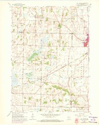
1960 Map of Lima Center
USGS Topo · Published 1972About this map
The agricultural plains of Lima and Johnstown are defined by a network of drainage creeks and the steel path of the Chicago Milwaukee St Paul and Pacific railroad. Centered on the settlement of Lima Center, this survey illustrates a landscape of established family farms and local institutions, such as North Lima Ch and the Lima Center Cem. To the east, the edge of Whitewater begins to expand, with its High Sch and urban boundary marked by recent revisions.
Find a feature on this map
22 named features on this map. Tap any name to fly to it.
Don’t see what you’re looking for? This feature index may not catch every label — zoom into the map to look around manually.
Map Details
Editions of this 1960 Lima Center Map
3 editions found
Other maps of this area

1891 · Koshkonong
USGS Topo · 1:62,500

1892 · Whitewater
USGS Topo · 1:62,500

1893 · Delavan
USGS Topo · 1:62,500

1893 · Whitewater
USGS Topo · 1:62,500

1893 · Shopiere
USGS Topo · 1:62,500

1894 · Koshkonong
USGS Topo · 1:62,500

1903 · Whitewater
USGS Topo · 1:62,500

1906 · Koshkonong
USGS Topo · 1:62,500

1924 · Whitewater
USGS Topo · 1:62,500

1954 · Rockford
USGS Topo · 1:250,000