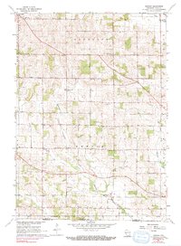
1962 Map of Newark
USGS Topo · Published 1991About this map
Orfordville stands at the northwestern corner of this Rock County landscape, where the C&NW railroad cuts a diagonal line across the rural townships of Plymouth and Spring Valley. The area is characterized by a dense network of early social centers, featuring numerous rural schools and churches that served the agricultural community during the mid-20th century. Notable landmarks include the Luther Valley Ch and several education sites like Fisher Sch and Pleasant Hill Sch.
Find a feature on this map
26 named features on this map. Tap any name to fly to it.
Don’t see what you’re looking for? This feature index may not catch every label — zoom into the map to look around manually.
Map Details
Editions of this 1962 Newark Map
3 editions found
Other maps of this area

1891 · Janesville
USGS Topo · 1:62,500

1893 · Janesville
USGS Topo · 1:62,500

1893 · Brodhead
USGS Topo · 1:62,500

1918 · Rockford
USGS Topo · 1:62,500

1932 · Pecatonica
USGS Topo · 1:62,500

1936 · Pecatonica
USGS Topo · 1:62,500

1938 · Rockford
USGS Topo · 1:62,500

1954 · Rockford
USGS Topo · 1:250,000

1955 · Rockford
USGS Topo · 1:250,000

1958 · Rockford
USGS Topo · 1:250,000