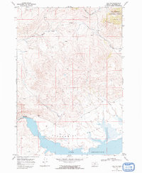
1968 Map of Lima Dam
USGS Topo · Published 1972About this map
Lima Reservoir dominates the southern landscape of this high-altitude Montana basin, held back by the Lima Dam Spillway 6577 at the head of the Red Rock River. The topography transitions from the broad flats of the Centennial Valley into the steep, rising ridges of the Clover Divide, where numerous drainages like Express Creek and Shineberger Creek carve through the terrain. To the northeast, the boundary of the Beaverhead National Forest marks the higher elevations where West Fork Blacktail Deer Creek begins its descent. This 1968 field survey illustrates a landscape primarily defined by water management and public lands, featuring a Gaging Sta near the dam and a network of named springs and creeks that reflect the area's importance to regional irrigation and livestock grazing in the late 1960s.
Find a feature on this map
15 named features on this map. Tap any name to fly to it.
Don’t see what you’re looking for? This feature index may not catch every label — zoom into the map to look around manually.
Map Details
Editions of this 1968 Lima Dam Map
2 editions found
Other maps of this area

1955 · Dubois
USGS Topo · 1:250,000

1958 · Dubois
USGS Topo · 1:250,000

1968 · Corral Creek
USGS Topo · 1:24,000

1968 · Whiskey Spring
USGS Topo · 1:24,000

1968 · Lima Dam
USGS Topo · 1:24,000

1968 · Snowline
USGS Topo · 1:24,000

1968 · Vinegar Hill
USGS Topo · 1:24,000

1968 · Monida
USGS Topo · 1:24,000

1968 · Henry Gulch
USGS Topo · 1:24,000

1968 · Antone Peak
USGS Topo · 1:24,000