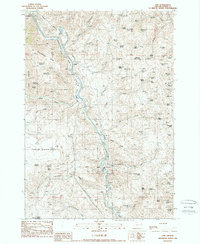
1988 Map of Lime
USGS Topo · Published 1988About this map
The Burnt River carves a deep path through Baker County, Oregon, defining the industrial and transit corridor shown in this late-1980s survey. This specific stretch of the canyon is a corridor for history and infrastructure, where the Oregon Trail runs parallel to modern utility developments like the Wooden Pole Trans Line and a prominent Pipeline. The settlement of Lime anchors the southern portion of the map, characterized by its extensive Quarry operations and industrial sites like the Substation and Pumping Station.
Find a feature on this map
87 named features on this map. Tap any name to fly to it.
Don’t see what you’re looking for? This feature index may not catch every label — zoom into the map to look around manually.
Map Details
Editions of this 1988 Lime Map
This is the sole edition of this map. No revisions or reprints were ever made.
Other maps of this area

1915 · Pine
USGS Topo · 1:125,000

1951 · Huntington
USGS Topo · 1:62,500

1952 · Olds Ferry NW
USGS Topo · 1:24,000

1952 · Olds Ferry
USGS Topo · 1:24,000

1952 · Olds Ferry
USGS Topo · 1:62,500

1955 · Baker
USGS Topo · 1:250,000

1957 · Durkee
USGS Topo · 1:62,500

1957 · Mineral
USGS Topo · 1:62,500

1959 · Baker
USGS Topo · 1:250,000

1980 · Brogan
USGS Topo · 1:100,000