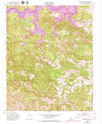
1948 Map of Lime Mountain
USGS Topo · Published 1979About this map
Nacimiento Reservoir dominates the northern reaches of this terrain, where the Nacimiento River is impounded against the rising slopes of the Santa Lucia Range. This 1970s revision, based on earlier Army Map Service data, documents a landscape of complex drainage systems. Tributaries such as Las Tablas Creek and Dip Creek carve deep into the ridges, converging toward the reservoir. In the southern half of the map, Camp Natoma sits near Town Creek, indicating the area's use for recreation and organized camps during the mid-20th century. The namesake Lime Mountain stands as a prominent peak, anchoring the western topography where steep contouring reflects the difficult approach for early surveyors. Small infrastructural details, such as a solitary Water Tank, provide localized markers for those tracing historical land use or property boundaries in this part of San Luis Obispo County.
Find a feature on this map
11 named features on this map. Tap any name to fly to it.
Don’t see what you’re looking for? This feature index may not catch every label — zoom into the map to look around manually.
Map Details
Editions of this 1948 Lime Mountain Map
4 editions found
Other maps of this area

1919 · Bryson
USGS Topo · 1:62,500

1919 · Bradley
USGS Topo · 1:62,500

1919 · Adelaida
USGS Topo · 1:62,500

1919 · San Simeon
USGS Topo · 1:62,500

1932 · Adelaida
USGS Topo · 1:62,500

1937 · San Simeon
USGS Topo · 1:62,500

1941 · Bradley
USGS Topo · 1:62,500

1941 · Bryson
USGS Topo · 1:62,500

1942 · Adelaida
USGS Topo · 1:62,500

1942 · Bryson
USGS Topo · 1:62,500