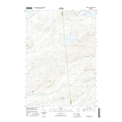
2016 Map of Limekiln Lake
USGS Topo · Published 2016About this map
Adirondack Park lands dominate this territory within Webb, where the Herkimer Co and Hamilton Co boundary divides a landscape defined by complex water systems and high summits. Centered on Limekiln Lake, the map traces the intricate drainage of the South Branch Moose River and the Indian River. The terrain is marked by distinct peaks including Higley Mtn, Mt Tom, and Stink Lake Mtn, alongside the geological depression of Deadmans Gulch. A network of remote lakes and ponds, such as Mitchell Ponds, Pico Lake, and Harry Ponds, illustrates the glacial topography of the region. Access is limited to rustic routes like Indian Lake RD and Campsite RD, highlighting the area's role as a preserved wilderness near the headwaters of the Fulton Chain Lakes.
Find a feature on this map
59 named features on this map. Tap any name to fly to it.
Don’t see what you’re looking for? This feature index may not catch every label — zoom into the map to look around manually.
Map Details
Editions of this 2016 Limekiln Lake Map
This is the sole edition of this map. No revisions or reprints were ever made.
Other maps of this area

1900 · Canada Lake
USGS Topo · 1:62,500

1901 · Old Forge
USGS Topo · 1:62,500

1903 · Big Moose
USGS Topo · 1:62,500

1903 · West Canada Lakes
USGS Topo · 1:62,500

1903 · Raquette Lake
USGS Topo · 1:62,500

1950 · Utica
USGS Topo · 1:250,000

1954 · Old Forge
USGS Topo · 1:62,500

1954 · West Canada Lakes
USGS Topo · 1:62,500
1954 · Raquette Lake
USGS Topo · 1:62,500

1954 · Big Moose
USGS Topo · 1:62,500