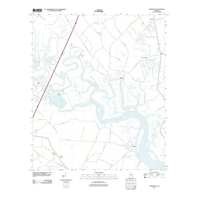
2011 Map of Limerick SE
USGS Topo · Published 2011About this map
Sunbury and the surrounding marshlands of coastal Georgia are defined by a complex network of winding waterways including the Jerico River, Belfast River, and Laurel View River. This 2011 survey documents the rural character of the region just before the expansion of modern residential developments began to more heavily alter the landscape. Genealogical interest is particularly high in this area, with several significant burial sites documented, such as the Old Dorchester Cemetery and New Dorchester Cemetery near Isle of Wight. The settlement of Belfast sits at a strategic bend in the river, while further east, the Tivoli River Bridge carries Belfast Keller Rd across the namesake river. The intricate tidal creeks like Demeries Creek and Dickinson Creek illustrate the low-lying topography that has dictated local transportation and land use for generations, from the historical river-based economy to the modern road networks like Sunbury Rd and Laurel View Rd.
Find a feature on this map
55 named features on this map. Tap any name to fly to it.
Don’t see what you’re looking for? This feature index may not catch every label — zoom into the map to look around manually.
Map Details
Editions of this 2011 Limerick SE Map
This is the sole edition of this map. No revisions or reprints were ever made.
Other maps of this area

1920 · Sapelo River
USGS Topo · 1:62,500

1920 · Limerick
USGS Topo · 1:62,500

1928 · St Catherines Island
USGS Topo · 1:62,500

1943 · St Catherines Island
USGS Topo · 1:62,500

1943 · Sapelo River
USGS Topo · 1:62,500

1944 · Limerick
USGS Topo · 1:62,500

1944 · Ossabaw Island
USGS Topo · 1:62,500

1945 · St. Catherine's Island
USGS Topo · 1:62,500

1945 · Ossabaw Island
USGS Topo · 1:62,500

1945 · Sapelo River
USGS Topo · 1:62,500