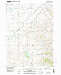
1998 Map of Lincoln Creek
USGS Topo · Published 2002About this map
The Fort Hall Indian Reservation dominates the landscape of Bingham County, Idaho, where the high desert terrain meets a sophisticated network of irrigation and river systems. Central to this map is the Lincoln Creek Valley, a topographic corridor shaped by the Lincoln Creek and flanked by the Blackfoot River to the north. This area reflects a mid-20th-century transition in Western land use, where historical markers like the Fort Hall No. 2 Historic Site sit amidst a complex grid of water engineering, including the Idaho Canal, Reservation Canal, and Portneuf Presto Ditch. Local transit is defined by rural corridors such as Cosgrove Road and East Weeding Lane, which connected the outlying settlement of Wapello to the scattered cemeteries and farmsteads that define this high-plain community.
Find a feature on this map
26 named features on this map. Tap any name to fly to it.
Don’t see what you’re looking for? This feature index may not catch every label — zoom into the map to look around manually.
Map Details
Editions of this 1998 Lincoln Creek Map
This is the sole edition of this map. No revisions or reprints were ever made.
Other maps of this area

1940 · Blackfoot
USGS Topo · 1:62,500

1943 · Blackfoot
USGS Topo · 1:62,500

1950 · Goshen
USGS Topo · 1:24,000

1951 · Higham Peak
USGS Topo · 1:24,000

1952 · Goshen
USGS Topo · 1:24,000

1955 · Lincoln Creek
USGS Topo · 1:24,000

1955 · Rose
USGS Topo · 1:24,000

1955 · Firth
USGS Topo · 1:24,000

1955 · Yandell Springs
USGS Topo · 1:62,500

1955 · Idaho Falls
USGS Topo · 1:250,000