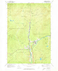
1967 Map of Lincoln
USGS Topo · Published 1973About this map
The Pemigewasset River corridor serves as the primary artery for settlement and tourism in this 1960s study of the White Mountains. The town of Lincoln and the neighboring village of North Woodstock anchor the valley, showing a mid-century landscape where industry and recreation meet. The Boston and Maine railroad line parallels the river, passing through Fairview while the newly established Kancamagus Highway begins its eastward ascent into the White Mountain National Forest.
Find a feature on this map
80 named features on this map. Tap any name to fly to it.
Don’t see what you’re looking for? This feature index may not catch every label — zoom into the map to look around manually.
Map Details
Editions of this 1967 Lincoln Map
4 editions found
Other maps of this area

1928 · Plymouth
USGS Topo · 1:62,500

1928 · Rumney
USGS Topo · 1:62,500

1929 · Moosilauke
USGS Topo · 1:62,500

1929 · Franconia
USGS Topo · 1:62,500

1931 · Plymouth
USGS Topo · 1:62,500

1932 · Franconia
USGS Topo · 1:62,500

1932 · Rumney
USGS Topo · 1:62,500

1932 · Moosilauke
USGS Topo · 1:62,500

1949 · Portland
USGS Topo · 1:250,000

1950 · Lewiston
USGS Topo · 1:250,000