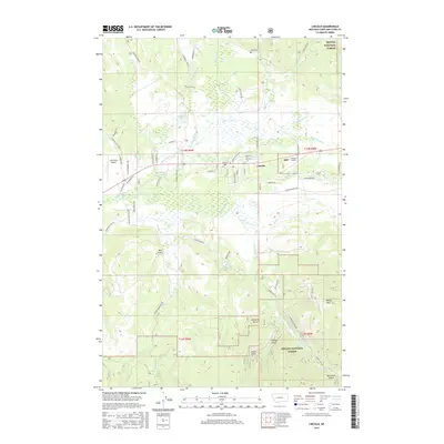
2017 Map of Lincoln
USGS Topo · Published 2017About this map
Lincoln serves as the central hub for this high-country landscape, where the Blackfoot River winds through the valley floor. The settlement pattern follows a grid of numbered streets and avenues, including Main St, bordered by the expansive Helena National Forest. Topography is defined by a series of drainages and peaks, notably Baldy Mtn to the southeast and various gulches like Bear Gulch and McCarthy Gulch. The presence of Lincoln Airport and the smaller Cain Ranch Airport suggests the importance of aviation in this mountainous terrain. Local history and genealogy researchers will find the Tuck Cem located north of the town center, while hydrological features like Smith Lake and the Stonewall Creek drainage illustrate the watershed that feeds the Blackfoot. The network of forest roads, such as Stemple Pass Rd and N Beaver Creek Rd, provides a clear view of the access routes into the surrounding timberlands.
Find a feature on this map
72 named features on this map. Tap any name to fly to it.
Don’t see what you’re looking for? This feature index may not catch every label — zoom into the map to look around manually.
Map Details
Editions of this 2017 Lincoln Map
This is the sole edition of this map. No revisions or reprints were ever made.
Other maps of this area

1889 · Helena
USGS Topo · 1:250,000

1893 · Helena
USGS Topo · 1:250,000

1899 · Helena
USGS Topo · 1:250,000

1903 · Coopers Lake
USGS Topo · 1:125,000

1903 · Helena
USGS Topo · 1:250,000

1947 · Butte
USGS Topo · 1:250,000

1955 · Choteau
USGS Topo · 1:250,000

1957 · Choteau
USGS Topo · 1:250,000

1958 · Butte
USGS Topo · 1:250,000

1958 · Choteau
USGS Topo · 1:250,000